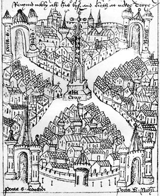
This drawing reproduces the (colour) original in the
Mayor's register held at the City of Bristol Record Office
In later centuries, antiquarians might present town maps in the context of a topographical description. Ricart's map of Bristol depicts the key topographical features of central Bristol, within the walls. Yet it is at the same time a somewhat idealized form, and was positioned between a mythical account of the ancient lineage of British kings – traced back to Trojan refugee Brutus (reputed founder of London) and culminating in the prince held to be the founder of Bristol – and a more historical list of pre-Conquest and post-Conquest rulers of England. Thus Bristol is portrayed as part of the ordained authority structure of the realm. Curiously, but perhaps coincidentally, the illustration (after allowance is made for stylization) more closely approximates the layout of Bristol in the early form it had, around the close of the eleventh century, than that with which Ricart would have been familiar at the close of the Middle Ages, much expanded by urban sprawl.
The circle of walls is punctuated by four sturdy and imposing gates, portals to a crossroads dividing the town into four equal quarters, the whole centering upon the High Cross, itself flanked on several sides by city churches that were a focus for communal gathering and a symbol of common values. The portrayal conveys a sense of balance, order, and orderliness; it appears an almost ritualistic space – a suitable setting for civic procession to emphasize, simultaneously, principles of solidarity and hierarchy. The town is divided into components, just as was the political structure of urban society, yet all are clearly integral parts of a whole, defined and held together as a single community by the cycle of walls.
An earlier, less developed, but more common symbolism of urban representation simply portrays the two dimensions, or authorities, of society – secular and ecclesiastical – whose buildings, densely packed around a public space, the whole enclosed within a ring of walls, guarded by towers and gateways. Examples are found in the early fourteenth century Luttrell Psalter and in a late fifteenth century copy of John Lydgate's The Life of Our Lady (below).
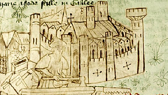
Here the town walls, in front of which is shown a
carpenter (representing Joseph), serve not only to delineate the town
but to distinguish it as an independent jurisdiction from the
surrounding countryside. From a manuscript in the Bodleian Library,
(slightly colourized by me for emphasis).
The very fact that such depictions are generalized and idealized provides us with an alternative perspective (counterbalancing the often particularistic written records produced by urban administrations) on how towns were conceived by their inhabitants and perceived by outsiders, as ordered and governed communities with distinctive characteristics. In contrast with the medieval conceptualization, historians attempting today to understand and characterize towns prefer to emphasize the interdependence of strictly urban and rural elements – that is, both intra-mural and extra-mural areas.
At an even more fundamental level, the depiction of Bristol is a late expression of the common medieval visual archetype of a city, informed by the interplay between Classical philosophy about the ideal structure of a secular state and Christian cosmology, focused on the Heavenly City, after which earthly counterparts were expected to model themselves.